A creek or river has two directions: upriver or down. Easy to navigate. The
winding creeks, bays and marshes of the Chesapeake look, from the air, like a
tangled forest, Mirkwood perhaps. From the water, the view is of a circle of sea
and tree woven together like a mare's tail in a high wind.
I guess I should have stayed with the Vikings. But then I wouldn't have had
an adventure. And adventures are things you tell stories about after you survive
them.
It started at the butt crack of dawn, before it actually; me, in the dark,
zombieing around finding breakfast and the last things I needed to throw in my
buddy's Subaru with the boat gear. I don't do Butt Crack of Dawn. And I really
truly deeply loathe navigating the traffic on 83 south and anywhere near
Baltimore. So I rode shotgun and thought about sleep, but ended up with a big
fat coffee from a pit stop in Mary's land instead.
We headed south, along the western edge of the Chesapeake Bay (laregest
estuary in North America). Through Baltimore, still sleeping in the early
Saturday morning light, silvering its way around tall buildings, the Aquarium,
tall ship Constellation in the harbor. South, south with D.C. far off to the
west, up the Potomac. Our destination, a small farm in southern Maryland, lay
near the other end of the Potomac. There, in a slip at the end of Canoe Neck
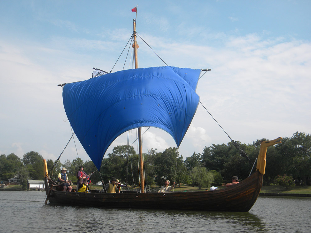
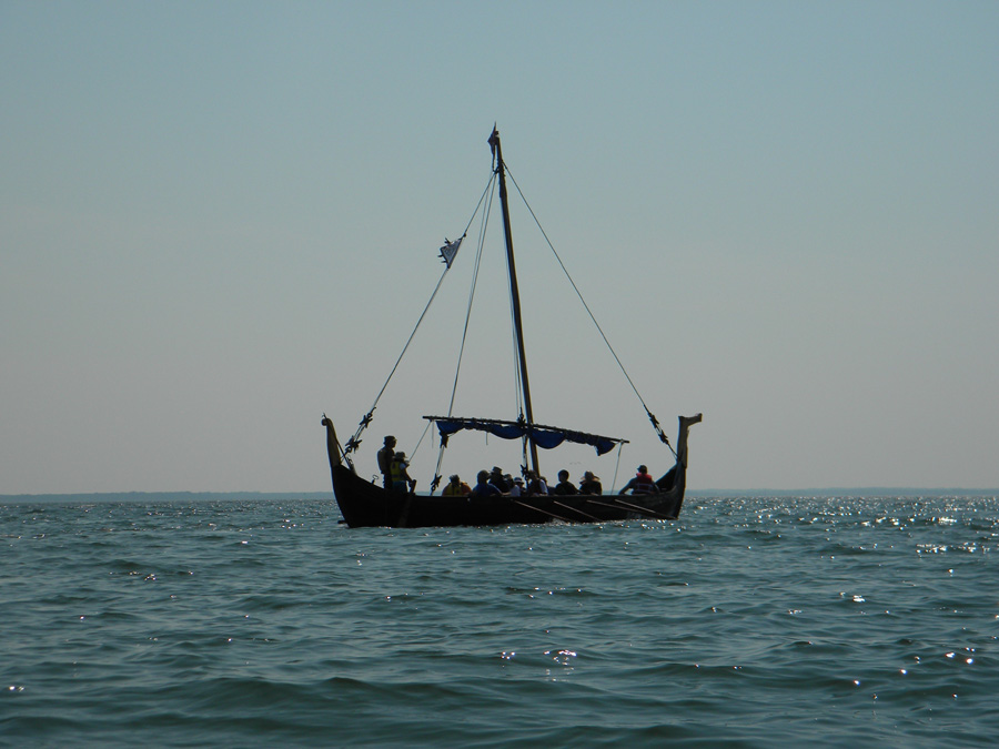
Creek, off St. Clement's Bay, off the Potomac, lies a forty foot Viking Longship
called Sae Hrafn, (she's docked at the house of a guy who flies blimps, so the
Longship captain and the Blimp Captain live on the same road... really!).
The ship is owned by the Longship Company, a doughty crew of serious amateur
historians and reinactors fascinated by the Viking Age. We are computer wizards,
cinematographers, artists, writers, fixers of engines, retired Park Service, and
at least one rocket scientist (really; he works for NASA). If you show up for a
voyage (it's free, but donations always accepted) you'll probably find someone
wearing a T-shirt with Viking runes on it that say: if you can read this you are
a Viking, or "Viking World Tour" (in the style of rock concert T-shirts) with a
list of historical high points of Norse culture (often battles and raids). At
least half a dozen crew will be wearing Thor's hammers, and some of us may also
have the Nerf version of Mjolnir (from the Marvel Comics' Thor film) on our
desk.
We pull up to the crumbling tobacco barn, load ship's gear into trucks and
cars, drive down the long farm lane to where the land ends. We load the ship, I
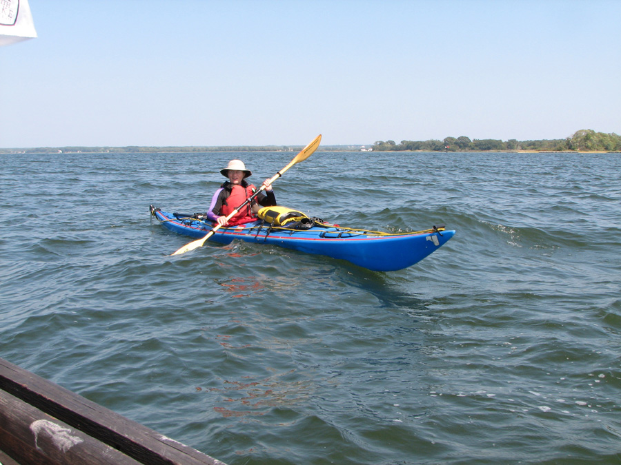
load the kayak... in about the same amount of time. A 1-person crew has to have
all the safety/survival gear the big ship has, with less crew to load it. I have
food, water, canned coffee (all the necessities of life), first aid,
windbreaker, bilge pump, towline, more water, spare paddle, fins (to help me
swim back up onto the boat if I dump), camerabag, cell phone tucked into an
Otter drybox in my PFD pocket. I don diveskin (protection from sunburn and sea
nettles) and hat and river sandals and PFD, shoved the kayak down a short grass
slope into the cool waters of Canoe Neck Creek. Here the world is sandy bottom
(unless it's mucky silt), semi-saltmarsh (we're as far down the west side of the
Bay as Assateague Island is down the east coast), farms, wooded treelines,
scattered houses, and a few marinas out there, somewhere, where there is more
boat traffic.
The new crew (visitors on the ship for the first time) hear the articles read
(rules of the Ship), and get a demonstration of rowing commands. Frogging oars
and catching a crab have nothing to do with local wildlife. The new crew
includes a lady who grew up in Hawaii (who may or may not have had ancestors who
sailed there a thousand years ago), her husband (who may or may not have had
ancestors who sailed the North Atlantic a thousand years ago) and a charming
Halfling (our favorite moniker for children, a reference, of course, to the
beloved Hobbit). The ship is readied, the docklines undone, the crew sets oars
and Sae Hrafn (Sea Raven) slips out of the slip.
I back paddle, shooting video, some stills (easier to upload quickly, videos
require editing, a coherent storyline and music). We head out into the creek,
beating against a brisk 8-10 knot wind, singing sea chanties (the bawdier ones
are left behind as we have a Halfling aboard). I paddle rings around the ship,
literally. They are chugging along under oars at a pace that leave me drifting
in their wake, occasionally dipping a paddle into the drink. I can charge ahead,
turn around and get shots as they pass. Swing behind, and cross the stern firing
video from a camera (a Nikon Coolpix L100) rigged with a bit of aquarium hose
covered wire so I can hold it in my teeth and keep paddling. Aboard, Captain
Dave has the new HP Go Pro slung around Sae Hrafn's dragonwolf figurehead's neck
taking shots of the action aboard.
Out into the sun, bright silver glinting off ever choppier waves as the water
opens up before us. Most of the new crew fall into the rhythm of rowing, and
watch changes (so rowers can rest). I paddle, with no watch changes, but at a
slow enough pace (tracking the ship) to relax. The Halfling takes the Helm; a
tiller attached to a steerboard (hence the word "starboard"), the tiller carved
to look like a raven's head. Someone mentions that Blackistone Island (now known
as St. Clement's Island) lies ahead, there beyond the mouth of St. Clement's
Bay, and we should make for it. Our one Captain and Founder is Bruce
Blackistone, who seems to be related to the founders of the island. He is
aboard, and it seems proper for the Captain to visit his Ancestral Holdings. I
float in the ship's wake, swinging around shooting video, falling back to the
lee side of the ship (port, in this case), so as not to drift into the oarsmen.
The dim misty island stays dim and distant. They row, I paddle.
"Are we there yet?" no one says. We sing, we feel the wind, the chop dances
under our hulls. My bow shoots out of the water on oncoming waves. The camera is
high enough to not get wavesplash, the sun is shining, the wind is blowing, the
white gulls are crying...
...to the sea, to the sea, the white gulls are crying, the wind is blowing,
the white foam is flying. That's Legolas' song of the sea from J.R.R.Tolkien's
Lord of the Rings, perhaps my all time favorite bit of poetry, although it is
actually a sort of sad going away song. The rhythm is fine for rowing or
paddling, especially if you sing it in Elvish. Cormorants flap by, blue herons
stalk the edges of the water, an eagle flies overhead and vanishes into the
trees. The Elves would love this.
"Are we going to make landfall on the island?" I ask. I'm thinking I may have
had too much coffee for breakfast, and not enough potty breaks.
"Want to go scout ahead?" Since I can paddle considerably faster than they
can row, and have less stuff catching the ripping good headwind, it seems like a
good idea. I stuff the paddle in the water and shoot ahead. (Comparative Stuff
That Catches Wind 101: Me: me (the kayak has ridiculously low freeboard)...
Them: a few feet of freeboard, mast, rigging, manblocks, random boathooks spears
and axes, 40' hull, a dozen rowers, a sail furled on a yard, figurehead shaped
like a cross between a wolf and a dragon, tail high atop the sternpost, oars,
flags, cameras, the Captain's Chest, tiller, steerboard). For the
sailing-impaired: freeboard is how much of your boat sticks out of the water.
The sky is a still blue dome, spotted with sheep clouds and no chance of Thor
slaying frost giants with Mjolnir (no thunderstorms predicted). The wind is in
our faces kicking up waves. Still above, chaos below. A chart of the area shows
a sandy bottom varying in depth from foot-deep shoals to thirteen feet or so in
the channel. Wind blows the water, tide pulls it another direction, it bounces
off shoals, intersects with a powerboat wake, drops into the deep, ricochets off
riprap (the ubiquitous rock armour lining many shores, especially ones humans
have built stuff on, stuff they don't want washed out to sea when the sand
erodes). The waves rock, roll and collide, making a pattern like a horse
galloping over rough country in the dark. After awhile, my head is spinning
trying to keep up with the motion; not seasick, but kind of wishing it would all
just stand still for a minute. I focus up, on the non-moving horizon and the
motion under the hull starts to make sense again.
The ship is behind me now, a blit somewhere against a distant treeline. I
can't turn around to look; turning the nearly eighteen foot sea kayak is like
turning a truck... and while you're turning, waves are blasting you from all
angles, and at the height of the turn, blasting you dead broadside. Just turning
in the cockpit is a yoga maneuver, one best not done in bouncing waves... you're
likely to be twisted like a pretzel about the time you get a wayward broadside
and find yourself in the drink. So I paddle ahead, keeping an eye on the biggish
tree in the middle of St.Clements Island. I note the compass course as I start
away from the ship: the reciprocal heading is 210 (the direction I want to be
going on the way back). I actually learned to use a compass underwater; for our
dive test we had to navigate a triangle in about ten feet of visibility, and end
up back at our starting point.
Easy compared to navigating the Bay.
The low blueish line of trees that is Blackistone/Clements creeps closer. The
water to either side rolls away to the horizon. That must be the Chesapeake. I
think about turning around, to see where Sae Hrafn is. I think about turning
back; it's getting choppier and I am essentially alone. I have a whistle. I have
a cell phone. I soon learn that the primitive tech is far more useful. I eye the
beach; is that a dock? A ramp? Sand (easy to beach on)? Or riprap (impossible to
land on)?
The waves shift shape again, lower, reflecting waves bounce off the shore,
and the shallows beneath. I spot a dock, with guys fishing off it. I paddle up
and shout ahoy or something. They ignore me. I shout again, and ask if there's a
public landing. I get a blank look and something about their look and demeanor
suggests they might not speak English.
Now I know how Captain John Smith felt. He was the first Englishman to
explore the Chesapeake. He went in a small boat called a shallop (about the size
of Sae Hrafn) with a dozen or so guys, rowed and sailed into unknown territory.
He encountered people, but they did not share his language. He had a compass and
other navigational instruments, but had to make up his map as he went. He had no
support, no backup, just him and his crew. There's a spot on the modern map
called Stingray Point, not far from where we are rowing today; it's where Capt.
Smith saw a stingray in the shallows and ran it through with his sword. The ray
objected and stabbed Mr. Smith in return. The Goode Captain became so ill he
told his men to dig his grave... he managed to recover enough to have the ray
for dinner... and to go on to help create that Pocahontas myth.
I see sea nettles, but no stingrays. I do see a water taxi, and evidence that
Blackistone/Clements is now a tourist destination. I paddle under the dock in
some nice waves, yell something like "Ahoy the taxi!" and get someone who speaks
the same language. Yes, there is a boat ramp around the other side of the
island...and a potti.
The last thing I want to do at this point ispaddle around an entire %$#^%$#^
island. I look at the island; not very large, actually. I'll just go around that
point and see whats there. I really gotta go.
I pass a picnic area. Something decidedly Park Pottyish. Riprap and nowhere
to land. I keep paddling. The waves shiftshape, flaten, rise, reflect, bounce
off the riprap. I turn the corner and LO! there is an actual sand beach. rising
above it are bushes and trees in Victorian fall colors; deep greens and browns
and burgundys and rusts. And rising above that is a white house with a cuppola
on top which is a Light.
I haul the boat up on the beach, then haul it up farther. The last thing I
want is to call 911 and explain that I am stranded on an island because I didn't
park the boat correctly. I find the potty. I take some pics of the lighthouse,
and somewhere in there I play phone tag with the crew of Sae Hrafn.
I'm hauling the kayak up higher on the empty beach when I hear the muffled
sound of the Star Wars theme. I crack open the Otter box in my PFD pocket and
see the call is from Dave. "Hello? HELLO?!?"
bzzzzzt... the phone calls vanishes into the ether. I hastily dry my hands on
the least wet thing I can find and poke through the phone menu to find which
Dave number that was (I am tech-impaired, so this took a minute). I call back,
he calls back, call drops, I call back.
I can see for miles across the flatness that is the lower Potomac land and
seascape. I can't imagine what's blocking a cell signal. I move up the steps to
the lighthouse and the phone rings again. "HELLO?!?!?"
We establish that I made it to the island, and they didn't. The other tall
ships in the Bay have backup engines for conditions where they can't sail. Even
then, they often are much less efficient under power, or in the case of the 1768
Schooner Sultana, buck and snort like recalcitrant Shetland Ponies because their
hulls were designed to fly before the wind, not plow into it. Sae Hrafn's backup
engine is the dozen or so rowers aboard (the longship, shaped like a big canoe,
is not built for any kind of engine). We are investigating the use of a push
boat (much like the push boats used by Skipjacks) in our (hah hah) copious free
time. The wind has shoved Sae Hrafn into a near standstill. Without forward
motion, you can't steer her; the steerboard doesn't have enough water flowing
past it to be effective. Then the wind grabs her and shoves her sideways. the
rowers try to counteract this by rowing more on one side or the other. In a
kayak, you instinctively counteract the force of the wind and the shove of waves
with an extra stroke, a harder stroke, a longer stroke. On the longship, you are
coordinating 8 to 12 rowers, shouting orders over the wind that's shoving you
into the marsh.
They wisely have decided to turn around and sail back.
I am half an hour ahead of them, I haven't eaten anything except a few
granola bars since breakfast at 6am. I've been paddling since noon, it's now
about 2:30. I know I can't catch them once they set sail (I have paced them
under sail, but I can't paddle faster than they can sail, or make up a half hour
lead). I need to eat, and then I'm making the voyage back alone. I have a
compass course, and I can see their sail when I get farther up the creek (though
they might have dropped it by then). I down a few quick bites and contemplate
resting on the beach for a bit... I'll have the wind behind me, surfing on the
waves, but it will still be rough, a rest would be good.
I don't waste much time. I take a few pics and video of the light and the
beach to prove I was there. I batten everything down in the 'yak, dryboxes,
drybags, stowed. I shove her out into the waves and hop in, popping the
sprayskirt around the cockpit. I paddle around the island to the midpoint where
I first approached, set my compass course, look up the creek from which we came
and...
...there are two creeks. Separated by a bit of land. Two long stretches of
water, bordered by treelines and agricultural land and scattered houses. No road
signs. No arrows pointing "this way to longship landing". Left creek or right
creek? I look at the compass again. Looks like left creek. Unless I'm at the
wrong point on the island. Does that look familiar? Can't tell. Water. Trees. I
head out into open water, to where it stretches away to the far misty blue blur
that might be distant trees or clouds on the edge of the world. I dance on the
waves, they sweep up behind me, yawing the 'yak right and left, even with the
rudder down. I shove on the paddle, the 'yak surges forward, surfing the waves
home.
Finally the treelines around the creeks grow greener, nearer. I check the
compass a few more times; it seems like I am on the right track.
Then the bright red triangle of a daymark appears in front if me. Really, I
don't remember that. I look at the compas. I twist around and look back at the
island. Yep, this makes sense, that looks like what I was paddling toward.
How could I have missed the osprey condo with the big bright red triangle on
it? I call Dave, and raise the ship. Just want to make sure I'm on the right
track before I paddle up the wrong creek. Dave and Bruce check the chart aboard
Sae Hrafn, Can't find the red daymark, number 2. No really, I'm sitting infront
of it, it's here. What? what was that again? The phone crackles like a joke in a
horror film. I hear mumbled sounds, then "Oh, here it is."
And I am totally up the wrong creek, with two paddles. And they are telling
me it's St. Patrick's creek I am in.. and that I should be in Canoe Neck, and
that's to the north. I look that way and all I see is a long unbroken treeline.
I am convinced I am either in the correct creek or I need to be in the one to
the far right (east). A conversation ensues while I try not to drop the cell
phone in the wrong creek and the guys on the ship check the chart again. Unable
to visualize what they're telling me, I finally agree to go up the creek and
look for a marina. They'll come find me.
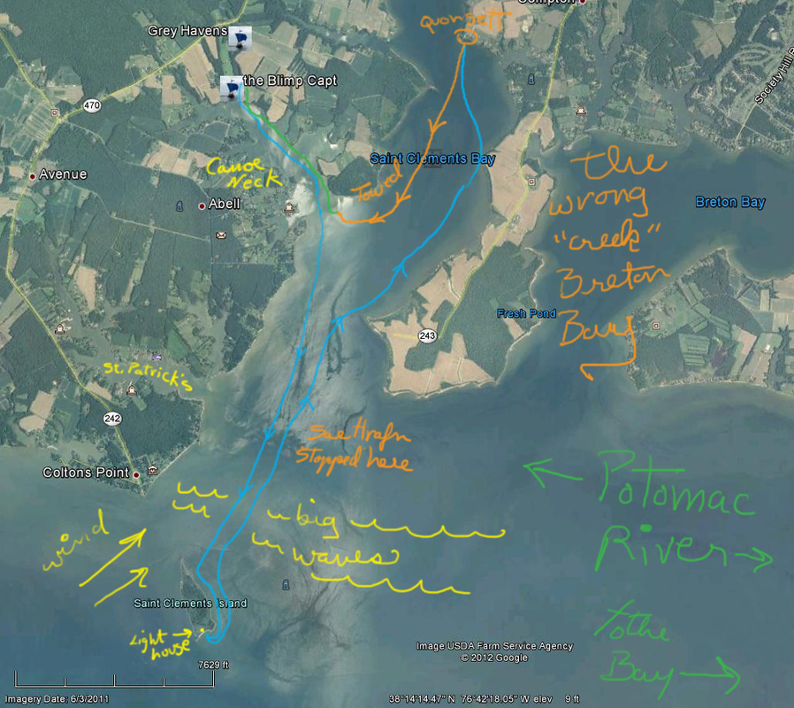
What I don't know, is that I am actually in the mouth of St. Clements Bay,
the "creek" to the right (east) is Breton Bay and would put me somewhere on the
far side of the world if I paddled up it. St. Patrick's Creek is to my left
(west) and Canoe Neck just beyond it to the north. I can't see either one of
them. In the Chesapeake region, creeks, rivers and bays make stumpy tree shapes,
branches going out short and thick and twisty, then abruptly ending in marsh and
land. The land interweaving with this ends in gazillions of puzzling peninsulas
called "necks". I was looking at a series of "necks" which from that angle,
looked like one solid treeline.
Stealth ninja creeks.
I paddle up the broad chunk of whatever water I'm in, looking for a marina.
Farms, stray houses, fields, riprap, wooded shores falling into the water as the
sand under the trees' feet is eroded by wind and weather and tide, a random dock
here, a tied up boat there. Nothing like a marina with an address that someone
could drive to. I see a large, official (ie: non-houselike) building with a
sandy beach at its feet. I pull the boat up on the beach, start to hike up to
the building, now clearly i can see it is a quonsett hut, a big silver half
cylinder (farm? secret meth lab?) surrounded, in the back, by tall chain link
fence. I pause, turn and pull the boat up farther, then tie it to a tree.
The building is empty of life, except for two vehicles parked out front, It
looks like some sort of business, and a sign suggests farm. then from somewhere
in back coems a deep throated bark, more like a dragon cough, then a roar, then
more, and I consider two things: the guard dogs will bring humans who I can ask
the address of and if it's OK for my friends to pick me up here... or the dogs
will jump the fence... or the dogs are guarding a meth lab. OK, that's three
things. I run back to the beach and untie the boat, head out, very tired, into a
lowering sun and falling light on an empty river.
Then I see a sailboat, going downriver under engine power. I paddle out
toward it, wave vaguely. Shout. Finally blow my whistle. They look, slow, turn
and come alongside.
"Is there a marina around here somewhere?"
"No, you're in St. Clements Bay. No marinas."
I explain where I came from and that I am lost and looking for St Clements
Creek, no wait, Canoe Neck. It's been a long day.
"It's up there." One sailor points vaguely at the distant treeish haze.
Pause... "you want us to throw you a line?"
Sure. Absolutely. Two random guys on a boat, towing me some random place I
can't see. They could be pirates. Axe murderers. Drug dealers. But probably not.
There's a kind of law of the sea at work here. The kind of thing that causes
three kayakers to go up to a 60 foot catamaran they've passed at the same spot
hours before and ask if everything's OK, and find out they're stuck on a
sandbar, and offer to tow them off. We didn't hook the towline up to the 'yaks,
we used the cat's anchor to kedge them off the bar. Law of the sea. The guy
struggling with his jet ski in the middle of a thunderstorm on the banks of the
Susquehanna while I cowered in my van (Thor may be one of my favorite mythic
characters, but I really hate thunderstorms)... I jumped out and helped him with
his boat, even though I loathe jet skis.
I run up behind the sailboat, one guy ties a line off to the 'yak's bow, they
pay out 30 feet or so of line and start the diesel. "Don't worry, we won't put
her up on plane or anything..." Sailor humor. Sailboats don't plane, powerboats
plane. Kayaks would plane, for about two seconds before they did some rather
spectacular special effects. We don't plane, we chug along, the wind blowing the
diesel fumes sideways, the 'yak gliding along at an unnatural speed, the rudder
keeping her in line with the big boat.
Somewhwere in here, Star Wars rings out in muffled splendor from my PFD
pocket. I juggle the phone, the paddle (trying not to catch a crab with it as
I'm being towed)... "I, ah, hitched a ride"...
A few minutes later, they untie the line at Canoe Neck Creek. I invite them
to come play with Vikings, and I paddle up the creek looking for the third cove
on the right, and certain that I'm going to have a chart next time.
10 mile paddle. Mostly into the wind. Plus 1.6 mi up St. Clement's Bay to the
quonsett hut (farm/beach), towed to mouth of Canoe Neck Creek by sailboat.
St.Clement's is actually Saint Clements Island State Park.
I was in the mouth of St. Clement's Bay, not St. Patricks Creek (to the
left/west at that point), and needed to go up the Bay (north) to Canoe Neck
Creek. I went north as far as the quonsett hut place (visible on Google Earth,
1.6 mi north of the mouth of Canoe Neck Creek).
The two creeks I was looking at were actually St. Clements Bay and Breton
Bay. Indeed the water to the right (Breton Bay) would have been way wrong.
The course out of Canoe Neck to St. Clements Is. is a long sweeping curve;
there is no point where it seems like you have made a sharp right turn to the
south. I was following the ship and shooting video, so I wasn't really paying
attention to the course.
Charts: never leave home without them.
www.longshipco.org We need a few good
rowers...uh...sailors. No experience
necessary.
 RSS Feed
